Kumano half a year after Typhoon #12
| Schauwecker's Japan Travel Blog by Stefan Schauwecker, webmaster of japan-guide.com |
This blog is intended to record some of my travel activities in Japan.
| previous post |
| next post |
2012/02/28 - Kumano half a year after Typhoon #12

Half a year ago in early September 2011, the Kii Peninsula (the large peninsula south of Kyoto and Osaka), was hit by Typhoon Number 12, one of the most destructive typhoons in recent decades in Japan. The typhoon's unusually slow pace caused abnormally large amounts of rain to fall onto the mountainous peninsula, causing rivers to swell into monsters that flooded towns, triggered innumerable land slides and killed over 50 people in Wakayama Prefecture alone.
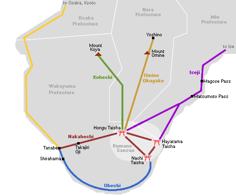
The Kumano Region at the southern tip of the peninsula, famous for its World Heritage shrines and pilgrimage trails, was among the worst hit areas. Many major roads remained closed for weeks, and the situation did not start to normalize until October. This week we paid a 2-day visit to Kumano to check on its state half a year after the other big natural disaster that hit Japan last year. Starting and ending in Shirahama, we visited the three shrines of Kumano in a circular route.

Nakahechi
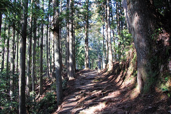
Nakahechi is the inland route leading from coastal Tanabe to Hongu Taisha, one of the three Kumano shrines. For an entire month, the important road connecting Tanabe with Hongu was closed to traffic, while the pilgrimage trail, which runs parallel to the road and is a popular 2-day hike among tourists, is still partially closed (for about a quarter of its length) to this date. The good news is that the trail will be fully reopened on March 10, 2012.
With the reopening of the remaining section of the Nakahechi pilgrimage trail, most popular pilgrimage trails will be accessible to tourists again with the exception of the challenging trails to Koyasan and Yoshino.


Hongu
The area around Hongu Shrine experienced heavy flooding as the water level of the Kumano River reached heights that most locals have not seen during their lifetimes. The main buildings of the Hongu Shrine - built at a higher elevation because of repeated floodings in past centuries - escaped damage unlike the town at the foot of the shrine, which was submerged by the river. However, most clean-up and repair efforts have been completed in the meantime.
We spent the night in the wonderful, historic hot spring town of Yunomine, one of three hot springs in the vicinity of Hongu Shrine. Yunomine did not suffer major direct damage from the typhoon, but its main access road remains interrupted due to a damaged bridge, making it impossible for large buses to reach the town. Cars and smaller buses, including free shuttle buses to/from Hongu, can reach Yunomine via two other, narrower roads.
On day two, we checked out Wataze and Kawayu, the other two hot spring towns near Hongu. Wataze's Watarase Onsen claims to have the largest outdoor baths (rotemburo) in Western Japan, which I enjoyed alone in the morning sun. Two smaller pools were closed for repair works, but that did not have any negative impact on my visit.
Kawayu suffered some damage from the river, which it lines and is named after, but most ryokan in town have reopened in the meantime. During the winter months (December through February), a large hot spring bath, called Senninburo, is digged alongside the river. Unfortunately, the bath was damaged earlier this month by heavy rainfalls (unrelated to last year's typhoon) and closed for this winter a few days ahead of its scheduled season end.


Shingu
Next we drove down along the Kumano River from Hongu to Shingu at the ocean coast. The important road between the two towns suffered damage along its entire length and remained closed for more than a month. Even half a year later there was ample of evidence suggesting how incredibly large and violent the river must have grown during the typhoon. At the mouth of the river, the town of Shingu also suffered flooding, but the main buildings of Hayatama Taisha, another of the three Kumano shrines, escaped any damage.


Nachi
Along the road to the last of the three Kumano shrines, Nachi Taisha, we drove through some of the worst hit areas, bringing back memories from our visits to the tsunami hit Sanriku Coast. When the Nachi River left its usual river bed, it destroyed numerous buildings and left behind a sight of destruction that remained quite visible even half a year later.
The shrine itself was hit by a landslide, but the main building escaped major damage. Nevertheless, some repair works were still going on around a side building, but they had almost no impact on the visit, as all other shrine and temple buildings were in good shape.
Nachi Waterfall, the tallest in Japan, also grew in size dramatically during the typhoon, causing some erosion damage around its base. But most of the infrastructure there has been reopened to tourists in the meantime, as well.


Although reminders of the natural disaster were still visible, we were able to confirm that the Kumano Region has fully re-opened to tourism. All major roads, bus and train lines were back in service, and all sights and most accommodations and pilgrimage routes have reopened. During our entire trip, we encountered no major inconveniences caused by the typhoon.

| previous post |
| next post |


