Autumn Color Report: Daisen
by Scott, staff writer of japan-guide.com
This journal is a log of my travels within Japan. Here you'll find my personal opinions on the places I've been and the things I've seen. Also expect to see the occasional review and editorial. Thanks for reading.
| previous post |
| next post |
2010/11/04 - Autumn Color Report: Daisen

Today Schauwecker and I visited Mount Daisen on the western end of Tottori Prefecture to check out the autumn colors along the trail up the mountain. At 1729 meters above sea level, Mount Daisen is the tallest mountain in the Chugoku Region, and the trail to the summit follows a ridge from a small ski and ryokan town on the northern side of the mountain.


Like the trails up Mount Fuji, the trail up Mount Daisen is divided up into ten sections with a station at roughly every 90 meters of elevation gain. There were no facilities, just simple markers set at each station along the way. Up until around the seventh station the trail was an endless series of steep steps that were mostly under the forest canopy. Occasionally there would be open spots where you could look out over the other slopes of the mountain.


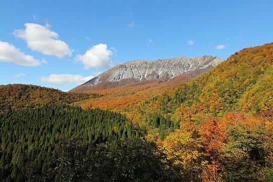
The primary autumn colors trees on Mount Daisen are yellow beech trees and a type of broadleafed maple that turns red. They are currently at their peak, which, unlike what we've seen on previous autumn report trips, is happening at the usual time rather than a few weeks late. While the hot summer didn't cause a delay in the colors on Mount Daisen, the unusual heat did effect the brilliance of the leaves and they are noticeably more muted than in previous years.

The treeline ends around the eighth station and the trail becomes a boardwalk through alpine shrubs and grasses for the rest of the hike to the summit. The information center at the bottom told us that there was 30 cm of snowfall the last few days, and some was still left on the trail making it slippery and dangerous at points.


The tenth station marks a secondary summit at 1709 meters high. This is the highest you can climb as the ridge that connects to the true summit is along an unstable knife's edge and is very dangerous to traverse. But the tenth station is only 20 meters short of the true summit and the view over Shimane and Tottori Prefectures and over the Sea of Japan was just as spectacular.


The winds at the top were bitter cold and we decided to descend after only a short stay. The climb down was hard on the knees due to all of the steps, and the trail was pretty busy the whole way down.

Near the end of the trail we detoured a little to stop by Daisenji Temple, a Buddhist temple of the Tendai sect.


After returning to the car we drove to a ski slope on the western face of the mountain to see how it looked. The trees were pretty much at the same state as from the north.


Finally we completed our trip by visiting an observation point with a view of the southern face of Mount Daisen. This area had the best colors of the day, and the trees along the road were especially brilliant. As today is right around the peak of the season, you can expect that Mount Daisen will continue to show good colors for another week or so before beginning to decline.
| previous post |
| next post |


